Drought conditions have worsened across major agricultural regions during a critical harvest period, with blowing dust creating hazardous conditions in parts of the Midwest, according to the latest U.S. Drought Monitor Summary. The U.S. Drought Monitor is jointly produced by the National Drought Mitigation Center at the University of Nebraska-Lincoln, the United States Department of Agriculture, and the National Oceanic and Atmospheric Administration.
Midwest
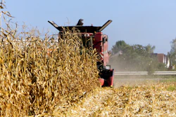
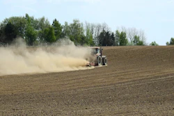
Intense short-term drought continued to spread across central Illinois, northern Indiana and northwest Ohio, where farmers reported visibility restrictions from blowing dust creating dangerous driving conditions during harvest operations. Temperatures running 10-20 degrees above normal added stress to already dry fields.
"Short-term drought, with localized longer-term impacts, continued to intensify this week from southwest Missouri northeast into central and northern Illinois, northern Indiana and northwest Ohio after another mainly dry week," the report stated. "In these areas, precipitation deficits grew while soil moisture and streamflow remained very low."
In eastern Kansas, abnormal dryness and moderate drought worsened in areas where streamflow and soil moisture levels dropped. Northeast Nebraska and southeast South Dakota also experienced expanding abnormally dry conditions that extended into northwest Iowa and southwest Minnesota.
South and Southeast
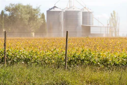
Agricultural drought impacts intensified in southern Georgia, where peanut crops are suffering, and in west-central Alabama, with both regions seeing extreme drought develop or worsen. The Carolinas experienced expanding drought conditions as precipitation deficits continued to mount.
Across Texas and Oklahoma, short-term dryness combined with above-normal temperatures led to widespread degradation. Parts of central and southwest Texas are experiencing both short and long-term drought impacts, while agricultural impacts were reported in Oklahoma, especially from the Oklahoma City area northward.
Some relief came to western Tennessee, northeast Arkansas and southeast Louisiana, where pockets of heavy rain provided improvement to drought conditions.
West
Northeast Montana saw the development of moderate drought where short-term precipitation and soil moisture deficits grew amid temperatures 5-15 degrees above normal. However, recent precipitation led to improvements across much of northern and southern Nevada, northern Utah, Idaho, Oregon and parts of Washington, where streamflow and soil moisture conditions improved.
Northwest
Drought conditions continued to worsen across much of the Northeast after a mostly dry week with temperatures 3-9 degrees above normal. Agricultural drought impacts worsened in southeast West Virginia, where severe drought developed.
Outlook
The five-day forecast through October 13 calls for mostly dry conditions across the Great Plains, Midwest and South. The East Coast may receive significant precipitation, with at least 1.5 inches expected along coastal areas from Florida to New Jersey.
For October 14-18, warmer-than-normal weather is favored across most of the central and eastern United States, especially in the southern Great Plains and Lower Mississippi River Valley. Below-normal precipitation is favored in the south-central and southeast U.S., extending northward to Lake Erie.
Western states may fare better, with above-normal precipitation favored across most of the West and into the northern Great Plains and western Great Lakes states, potentially aiding winter wheat establishment.