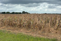
Very hot and dry conditions across the Western U.S. and Plains states during the past week led to rapid deterioration of drought conditions, particularly in the Upper Midwest and Northern Plains. Average temperatures soared well above normal levels, elevating evaporative demand and causing flash drought conditions to develop across Minnesota, Wisconsin and portions of the Dakotas according to the latest U.S. Drought Monitor. The U.S. Drought Monitor is produced by the National Drought Mitigation Center at the University of Nebraska-Lincoln, the U.S. Department of Agriculture, the National Oceanic and Atmospheric Administration and NASA.
The National Drought Mitigation Center’s flash drought composite map showed severe to extreme flash drought conditions across the Upper Midwest during the past week. In Minnesota, temperatures ran 2 to 8 degrees above normal, while numerous locations across the region ranked among their warmest or near warmest mean temperatures on record for the past 30-day period.
Hibbing, Minnesota, recorded its warmest mean temperature on record with a 6-degree departure from normal. Minneapolis/St. Paul Airport saw its second warmest period with a 5-degree departure, while Dubuque, Iowa, and Eau Claire, Wisconsin, also recorded their second warmest periods with 5-degree and 4-degree departures, respectively.
Heavy rains bring relief to Southeast
Rainfall totals ranging from 3 to 8 inches across North Carolina led to significant improvements in drought conditions statewide. Light to heavy rainfall accumulations of 1 to 8 inches were observed across the region, with the heaviest amounts in North Carolina and Virginia.
Widespread improvements were made in drought-affected areas of Tennessee, where rainfall has been well above normal during the past 30 to 60 days across much of the state. Isolated areas of northern Alabama, Georgia, and Florida received beneficial rains leading to improvements in drought-affected areas.
Western reservoirs remain at historic lows
The U.S. Bureau of Reclamation reported Lake Powell at 23% full, representing 33% of average for the date and the lowest on record for this date in the last 30 years. Lake Mead stands at 27% full, or 45% of average for the date, also the lowest on record for the date in the last 30 years.
The total Colorado River system sits at 33% of capacity, compared to 39% of capacity at the same time last year. California’s reservoirs continue to perform better, with Lake Shasta at 99% of average and Lake Oroville at 108% of average.
Monsoonal rains benefit Southwest
An active monsoonal pattern from June 15 to present has led to above-normal precipitation across Arizona, where percentages of normal have ranged from 150% to 250% above normal across southeastern, central, and northern portions of the state. Precipitation during the past 30-day period has been above normal in portions of Arizona and western New Mexico, boosting streamflow and soil moisture levels while improving vegetation health.
The National Weather Service’s 5-day forecast calls for heavy precipitation accumulations of 3 to 5 inches across portions of the Gulf Coast from southeastern Louisiana to west-central Florida. The 6-to-10-day outlook favors above-normal temperatures across most of the contiguous United States.