Drought conditions across the United States deteriorated this week as large parts of the country experienced little to no meaningful precipitation, expanding dry soils, and critically low snowpack in key western mountain regions. The latest U.S. Drought Monitor report highlights worsening conditions from the Pacific Northwest through the southern Plains and into the Southeast, with fire danger rising notably in Florida. The U.S. Drought Monitor is jointly produced by the National Drought Mitigation Center at the University of Nebraska-Lincoln, the United States Department of Agriculture and the National Oceanic and Atmospheric Administration.
A strong temperature gradient persisted, with below-normal temperatures in much of the East and above-normal readings across the West. Despite some mountain snow in the northern and central Rockies, snow-water equivalent levels remain below the 15th percentile, contributing to drought expansion in Oregon, Idaho, Montana, Wyoming, and western Colorado.
In the Northeast, moderate drought expanded in eastern Pennsylvania, central New York, and Massachusetts, driven by 2 to 6 inches of precipitation deficits over the past 30 to 60 days. Colder-than-average temperatures limited snowmelt benefits, while groundwater and streamflow concerns grew in parts of Connecticut, Rhode Island, and Massachusetts.
The Southeast saw light and uneven rainfall, with many areas receiving less than 25 percent of normal precipitation. Moderate to severe drought expanded across Alabama, Georgia, and the Carolinas, while extreme drought spread in parts of Georgia, South Carolina’s Upstate region, and North Carolina. Florida faces worsening conditions, with soil moisture below the 5th percentile in central and southern areas and Keetch-Byram Drought Index values reaching 700 in some locations, signaling extreme fire potential. Wildfire activity increased, prompting water shortage advisories in several districts.
The South continued to dry out, with Louisiana, Arkansas, Texas, and Oklahoma recording less than half their normal rainfall. Long-term dryness intensified in Deep South Texas, where some areas rank among the driest and warmest on record for the past six months.
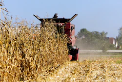
The Midwest remained mostly dry with expanding drought in Illinois and Missouri, where streamflows and groundwater levels fell below seasonal averages. Abnormal dryness also spread in parts of Minnesota and Iowa.
The High Plains faced minimal precipitation, with severe drought introduced in Nebraska’s Panhandle and moderate to severe drought expanding in eastern Wyoming, Colorado, and western Nebraska. Soil moisture deficits and above-normal temperatures contributed to surface drying.
In the West, light precipitation and patchy mountain snow failed to improve conditions. Snowpack levels remain critically low, with Colorado experiencing its worst snowpack on record. Warm temperatures limited snow accumulation, worsening drought in Utah, Nevada, and western Colorado. The Pacific Northwest saw some isolated improvements but also new areas of abnormal dryness.
Hawaii experienced heavy rainfall and snow on windward slopes, leading to short-term drought improvements, though leeward areas remained dry.
Looking ahead, forecasts predict widespread precipitation across much of the western and southern U.S. over the next week, with the heaviest rainfall expected from eastern Texas into Arkansas. California, the Great Basin, and the northern Rockies are also forecast to receive significant precipitation. However, the northern Plains may remain dry. Temperatures are expected to be above normal across much of the central and eastern U.S., while below-normal temperatures are favored along the West Coast and Alaska.