Summer thunderstorms produced scattered but beneficial rainfall across much of the Great Plains and Midwest this week, bringing drought relief to Nebraska, Kansas and parts of the Dakotas while Minnesota faced its most significant deterioration in months, according to the latest U.S. Drought Monitor report released this week. The report is jointly produced by the National Drought Mitigation Center at the University of Nebraska-Lincoln, the U.S. Department of Agriculture, the National Oceanic and Atmospheric Administration and NASA.
The wetter pattern resulted in improvements across much of the region, with degradations primarily confined to Minnesota and portions of South Dakota and Colorado. The heaviest rainfall occurred from eastern Iowa into western Indiana and across western and central Missouri, with western Kentucky also recording above-normal precipitation.
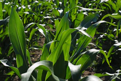
Great Plains see widespread improvement
Drought intensity eased where the heaviest rains fell across Nebraska, Kansas and South Dakota. Drought was eliminated in portions of northern Kansas and southeast Nebraska, marking significant progress for agricultural areas.
Above-normal precipitation occurred in southern Nebraska, northern Kansas, northern Nebraska into southern and central South Dakota, and across much of northern North Dakota. Temperatures were generally warmer than normal across the region, with portions of the Dakotas and western Nebraska averaging 9 to 12 degrees above normal.
However, relief was not uniform. Southeast South Dakota continued to miss significant rainfall, and the combination of short-term and long-term dryness allowed moderate and severe drought to expand in that area.
Areas along the foothills of the Rocky Mountains from Montana through Colorado remained largely dry. Degradation occurred in eastern Colorado, where extreme drought expanded in the north and moderate drought expanded across east-central portions of the state. Extreme drought was reduced slightly in southern Colorado following recent rainfall.
Minnesota faces cumulative drought effects
The most significant change in the Midwest occurred in Minnesota, where the cumulative effects of multiple dry years have affected much of the northern portion of the state, including the headwaters of the Mississippi River.
Moderate drought expanded and severe drought was introduced across the region. Below-normal precipitation extended from western Iowa into Minnesota and across much of central Wisconsin. Minnesota averaged temperatures 8 to 10 degrees above normal, exacerbating the dry conditions.
Other Midwest areas improve
Improvements to abnormally dry conditions and moderate drought occurred across northern Illinois, eastern Iowa, and northeastern and southern Missouri. Extreme drought was removed from western Kentucky, accompanied by improvements to moderate drought there and into southern Illinois.
Temperatures were mixed across the Midwest, with much of the region above normal. Near- to below-normal temperatures were observed from southern Missouri into Kentucky.
Impacts in the Plains have primarily affected winter wheat and forage production, and areas that have remained dry continue to experience elevated fire danger.
Elsewhere, drought conditions remain mixed across the country. The Northeast experienced expanding drought with extreme conditions introduced in parts of New Jersey, Delaware and Maryland. The Southeast saw improvements in Georgia, Florida and Alabama, though North Carolina and Virginia deteriorated.
The West remained largely dry except for portions of the Pacific Northwest and southern New Mexico, where above-normal precipitation occurred. A winter characterized by above-normal temperatures and below-normal snowpack continues to affect the region.
Looking ahead, forecasts call for the southern U.S. and portions of the Midwest to have the greatest potential for above-normal precipitation over the next five to seven days, while the northern Plains and Southwest are expected to receive less than 1 inch.